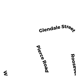
0 ROOSEVELT RD
Weymouth, MA02188
Owner Information
RUND RUSSELL N & KATHLEEN A
39 ROOSEVELT RD
WEYMOUTH, MA 02188


Property Details
0 ROOSEVELT RD is classified as a Developable Residential Land.
0 ROOSEVELT RD is valued at 206200. The land is valued at 206200 and the structures are valued at 0.
The most recent deed for 0 ROOSEVELT RD is recorded at the local registrar in Book 4706, Page 481.
Assessment data from fiscal year 2022.
Flood Data
According to the FEMA National Flood Hazard Layer, this property does not appear to be in a flood zone. It may also be in an area not yet reviewed. Nonetheless, confirm this information prior to taking any action.
To view the flood hazards around this property, create a FEMA "Firmette" Map of the area around 0 ROOSEVELT RD.
Broadband Internet Providers
| Provider | Type | Bandwidth (mbps) | |
|---|---|---|---|
| Verizon New England Inc. | DSL | 15 | 1 |
| Crown Castle Fiber | Fiber | 0 | 0 |
| VSAT Systems, LLC. | Satellite | 2 | 1 |
| HughesNet | Satellite | 25 | 3 |
| GCI Communication Corp. | Satellite | 0 | 0 |
| T-Mobile | Fixed Wireless | 25 | 3 |
| Comcast | Cable | 1000 | 35 |
| Viasat Inc | Satellite | 100 | 3 |
Broadband service provider data from December 2020.
Adjacent Properties
- 0 BROAD ST
Developable Industrial Land owned by NSTAR ELECTRIC COMPANY - 45 ROOSEVELT RD
Single Family Residential owned by WU YUN - 39 ROOSEVELT RD
Single Family Residential owned by RUND RUSSELL N & KATHLEEN A - 63 ROOSEVELT RD
Single Family Residential owned by KROPAS RICHARD J - 0 BROAD ST
Developable Industrial Land owned by MASSACHUSETTS ELECTRIC CO